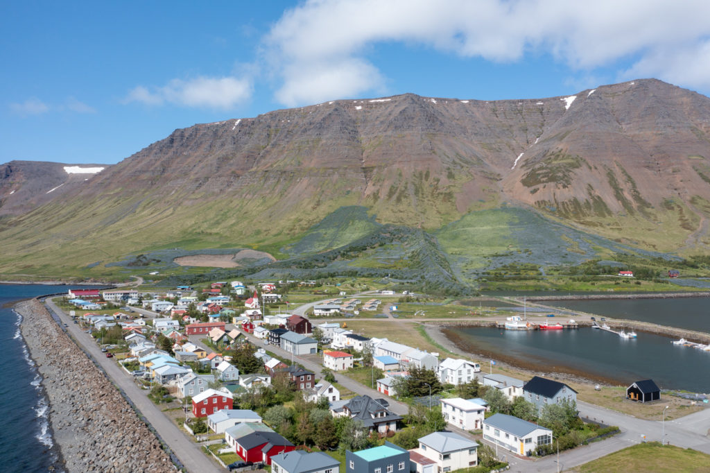
The project formed part of the Icelandic Civil Protection risk assessment process and was carried out in collaboration with ISOR, the Icelandic Road and Coastal Administration, the University of Iceland, and other specialist organisations.
Verkís was responsible for project management and participated in field investigations, mapping, and analysis aimed at identifying ground fissures, subsurface voids, and areas of geotechnical risk. The primary objective was to improve safety for emergency responders, support access to affected areas, and provide a technical basis for future recovery and development efforts.
The investigation revealed seven major fissure zones throughout the town, including extensive subsurface fractures and voids that were not visible at the surface. Some fissures were found to be approximately 80 centimetres wide and 5–6 metres deep, while the largest underground cavities extended to depths of 30 metres and reached widths of up to 5 metres.
The findings provide critical information for infrastructure repairs, urban planning, risk mitigation, and future development in Grindavík. The project established a systematic methodology for investigating and managing new ground movements and created an important technical foundation for the town’s long-term recovery and resilience.
The Challenge
Reykjavík Energy owns the Hellisheidi geothermal power plant, a combined heat and power plant located about 20 km from Reykjavík in south-west Iceland. The area is one of Iceland’s most active high enthalpy areas. A new area, at Gráuhnúkar, is being investigated for steam and fluid extraction. The purpose of the plants is to meet increased demand for electricity for industrial and domestic use and for hot water for heating. The 303 MWe geothermal power plant in Hellisheiði, Iceland, was commissioned in 5 stages during the years 2006-2011. The first stage was completed in 2006 with two high pressure geothermal turbines of 45 MWe capacity each. The second stage was completed in 2007 with one low pressure geothermal turbine of 33 MWe capacity. The third stage was completed in 2008 with two additional high pressure geothermal turbines, 45 MWe each.
In 2010 a heating plant for hot water generation was added to the plant, intended for district heating. The heat output of the first stage is 133 MWth and two further 133 MWth stages are to follow later. At the same time the Hellisheiði hot water main was put into service. The main is a 19,5 km long pipeline, 0,9-1,0 m in diameter, that carries hot water to Reykjavík. In 2011 the 5th stage of the plant was finished, which includes two new 45 MWe high pressure geothermal turbines, similar to the former turbines, situated in a new power house in Sleggjubeinsdalur.
The plant utilizes 500 kg/s of 180°C geothermal steam for electrical generation. The hot fluid is extracted from 30 wells, 2.000 – 3.000 m deep, and is led through steam and mist separators before entering the turbines. The high pressure steam gathering system operates at 9 bara pressure. The low pressure steam is generated with flashing of brine water from the steam separators at a pressure of 2 bara. The generating units are of single flow, single flash type with axial exhaust. Cooling is achieved through wet cooling towers of the counter flow type.
The main components of the electrical system for each unit consist of a 50 MVA generator, 50 MVA step-up transformer to 220 kV transmission voltage, an 11/11 kV transformer for connection to the 11 kV station service system and two 11/0,4 kV transformers for station service. The generating units, as well as the 11 kV and 0,4 kV distribution boards, are monitored and controlled by the state of the art control- and protection equipment.
Our Solution
Reykjavík Energy owns the Hellisheidi geothermal power plant, a combined heat and power plant located about 20 km from Reykjavík in south-west Iceland. The area is one of Iceland’s most active high enthalpy areas. A new area, at Gráuhnúkar, is being investigated for steam and fluid extraction. The purpose of the plants is to meet increased demand for electricity for industrial and domestic use and for hot water for heating. The 303 MWe geothermal power plant in Hellisheiði, Iceland, was commissioned in 5 stages during the years 2006-2011. The first stage was completed in 2006 with two high pressure geothermal turbines of 45 MWe capacity each. The second stage was completed in 2007 with one low pressure geothermal turbine of 33 MWe capacity. The third stage was completed in 2008 with two additional high pressure geothermal turbines, 45 MWe each.
In 2010 a heating plant for hot water generation was added to the plant, intended for district heating. The heat output of the first stage is 133 MWth and two further 133 MWth stages are to follow later. At the same time the Hellisheiði hot water main was put into service. The main is a 19,5 km long pipeline, 0,9-1,0 m in diameter, that carries hot water to Reykjavík. In 2011 the 5th stage of the plant was finished, which includes two new 45 MWe high pressure geothermal turbines, similar to the former turbines, situated in a new power house in Sleggjubeinsdalur.
The plant utilizes 500 kg/s of 180°C geothermal steam for electrical generation. The hot fluid is extracted from 30 wells, 2.000 – 3.000 m deep, and is led through steam and mist separators before entering the turbines. The high pressure steam gathering system operates at 9 bara pressure. The low pressure steam is generated with flashing of brine water from the steam separators at a pressure of 2 bara. The generating units are of single flow, single flash type with axial exhaust. Cooling is achieved through wet cooling towers of the counter flow type.
The main components of the electrical system for each unit consist of a 50 MVA generator, 50 MVA step-up transformer to 220 kV transmission voltage, an 11/11 kV transformer for connection to the 11 kV station service system and two 11/0,4 kV transformers for station service. The generating units, as well as the 11 kV and 0,4 kV distribution boards, are monitored and controlled by the state of the art control- and protection equipment.
The Result
Reykjavík Energy owns the Hellisheidi geothermal power plant, a combined heat and power plant located about 20 km from Reykjavík in south-west Iceland. The area is one of Iceland’s most active high enthalpy areas. A new area, at Gráuhnúkar, is being investigated for steam and fluid extraction. The purpose of the plants is to meet increased demand for electricity for industrial and domestic use and for hot water for heating. The 303 MWe geothermal power plant in Hellisheiði, Iceland, was commissioned in 5 stages during the years 2006-2011. The first stage was completed in 2006 with two high pressure geothermal turbines of 45 MWe capacity each. The second stage was completed in 2007 with one low pressure geothermal turbine of 33 MWe capacity. The third stage was completed in 2008 with two additional high pressure geothermal turbines, 45 MWe each.
In 2010 a heating plant for hot water generation was added to the plant, intended for district heating. The heat output of the first stage is 133 MWth and two further 133 MWth stages are to follow later. At the same time the Hellisheiði hot water main was put into service. The main is a 19,5 km long pipeline, 0,9-1,0 m in diameter, that carries hot water to Reykjavík. In 2011 the 5th stage of the plant was finished, which includes two new 45 MWe high pressure geothermal turbines, similar to the former turbines, situated in a new power house in Sleggjubeinsdalur.
The plant utilizes 500 kg/s of 180°C geothermal steam for electrical generation. The hot fluid is extracted from 30 wells, 2.000 – 3.000 m deep, and is led through steam and mist separators before entering the turbines. The high pressure steam gathering system operates at 9 bara pressure. The low pressure steam is generated with flashing of brine water from the steam separators at a pressure of 2 bara. The generating units are of single flow, single flash type with axial exhaust. Cooling is achieved through wet cooling towers of the counter flow type.
The main components of the electrical system for each unit consist of a 50 MVA generator, 50 MVA step-up transformer to 220 kV transmission voltage, an 11/11 kV transformer for connection to the 11 kV station service system and two 11/0,4 kV transformers for station service. The generating units, as well as the 11 kV and 0,4 kV distribution boards, are monitored and controlled by the state of the art control- and protection equipment.